Vandringen på Linnérundan gjordes i samband med en pressresa till Kristianstad med Visit Kristianstad, men alla tankar och åsikter är som vanligt mina egna.
Ett stenkast från Kristianstads centrum ligger ett våtmarksområde där allt liv kretsar kring Helge å. Genom alla tider har Helgeåns vatten påverkat Kristianstad och dess ängar med sina stora översvämningar och ända sedan 1700-talet har man försökt att tämja det oberäkneliga vattenflödet för att skapa fler åkrar och mer yta för bostäder. Det var inte förrän för 30 år sedan som man slutade använda området som soptipp och istället började inse områdets unika egenskaper. Sakta men säkert har området åter blivit det Everglades-liknande vattenland som Vattenriket är idag – ett unikt och Unesco-skyddat biosfärområde.

Familjevänliga Linnérundan
För att på ett enkelt sätt kunna uppleva Vattenriket och våtmarksområdet finns Linnérundan, en 6 kilometer lång promenadslinga/vandringsled som börjar och slutar i Vattenrikets besökscentrum Naturum. Även om Linnérundan både är lättillgänglig och familjevänlig, är den inte alltid tillgänglig. Vandringsleden är, som allt annat i Vattenriket, väldigt påverkad av Helgeåns vattenstånd. Om vattennivåerna är högre än 1,3 meter över havet är Linnérundans stigar vattentäckta och ej gångbara, så det gäller att kolla dagens vattennivåer innan man beger sig ut i området.
Idag när vi beger oss ut på Linnérundan är vattennivån 0,36 meter över havet, så det kommer att bli en perfekt (och torr) vandring, under en helt perfekt septemberdag. Helgeån svämmar oftast över under vårvintern och min svärmor har berättat om hur hon på vintrarna när hon var barn åkte skridskor över de vattentäckta åkrarna. Som mest har vattennivån i Helge å stigit 2,24 meter över havsnivån. Det inträffade 2002. Då var till och med delar av centrala Kristianstad och Tivoliparken under vatten.


Kanalhusets utomhusmuseum
Vi parkerar bilen vid Tivoliparken och börjar gå Linnérundan motsols från Naturum. Vi passerar förbi rader av överblommande nyponrosor innan vi kommer till vandringens första stopp – Kanalhuset. Ett utemuseum och fågelskådartorn som kort berättar om områdets historia och djurliv. I glasmontrarna visar man upp områdets fågelliv genom välsnidade träfigurer och tavlorna på väggen visar viktiga år i Kristianstads historia.
Kristianstad grundades år 1614 av den danska kungen Christian IV på denna plats just på grund av Helge å och dess våtmarker. Härifrån kunde båtar lätt ta sig ut i Östersjön, samtidigt som våtmarken fungerade som ett skydd för den utsatta staden. Även om Kristianstad byggdes som ett redigt fort med vallgrav, var hoten stora. Det härjade nämligen farliga svenskar i området. I och med freden i Roskilde 1658 föll Kristianstad i Sveriges händer och en ny era började för staden. År 1750 hade Kristianstad Skånes största hamn, med stor internationell handel. Det känns konstigt att tänka sig att stora segelfartyg en gång i tiden har seglat här i Helge å, när det idag nästan enbart går att ta sig runt i roddbåt.


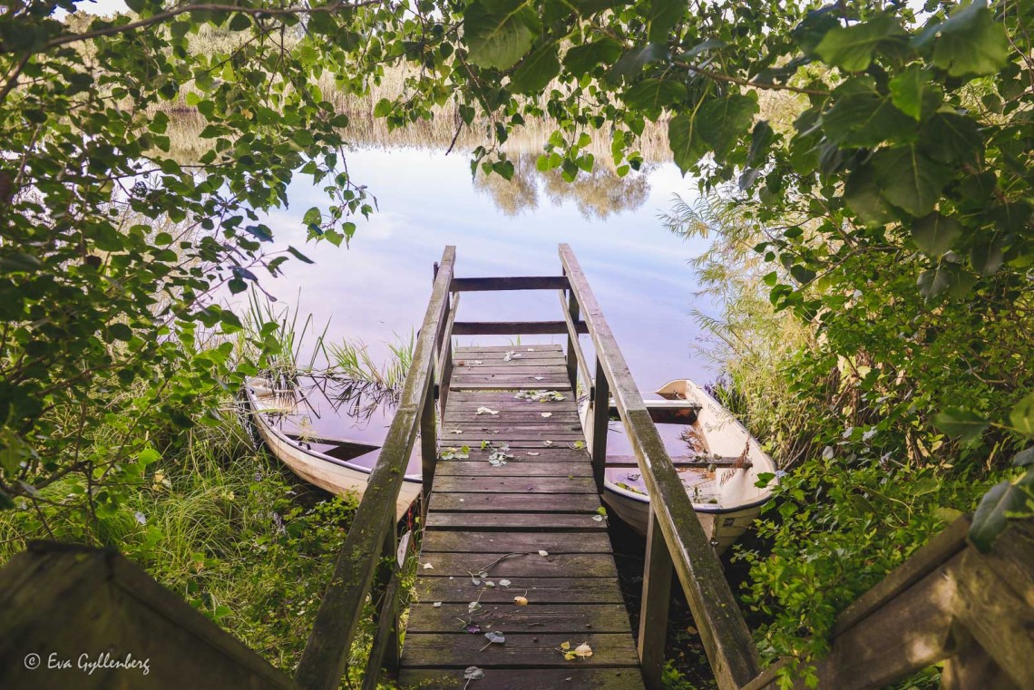
Helge å är alldeles stilla idag och av nattens regn återstår bara ett soldis och gnistrande vattendroppar på trädens blad. Vandringsleden fortsätter in i tjocka videsnår, över breda träspångar på pålar. Träspångarna är otroligt välskötta och lättvandrade och det är inga problem att promenera på träspångarna varken för oss eller för hunden.
Utefter Linnérundan sitter små skyltar med QR-koder som öppnar upp intressanta ljudberättelser om just den plats som du befinner dig på. Berättelserna är ofta runt tre minuter och väl värda att lyssna in på. Det känns nästan lite lyxigt att kunna få en guidad tur på våra egna villkor. Lyssna när du vill. Stäng av när du vill.


Naturreservatet Isternäset
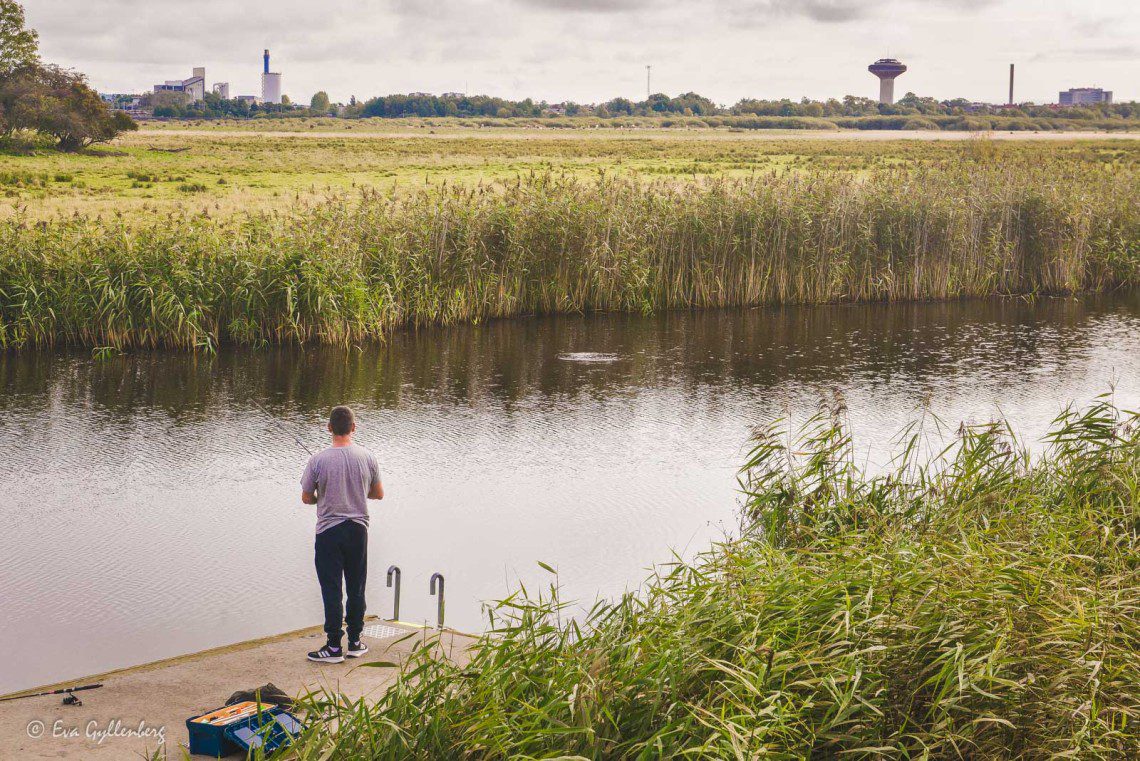
Vi passerar över en bro över en stor motorväg och kommer nu in i naturreservatet Isternäset. Isternäset är en stor strandäng, med en fågelsjö och mängder av boskap. Fågelsjön skapas när ängarna svämmar över och varje vår och höst är sjön fylld med fåglar. Idag när vi är här, är sjön fylld av flyttfåglar på väg söderut. Det är så mycket fåglar att ljudet nästan är öronbedövande. Främst ser det ut att vara gäss som tar en paus här på strandängen, men även en flock med någon mindre vadare har belägrat sig i sjön.
Några fågelskådare står helt stilla och tittar i sina gigantiska kikare. Jag gör ett försök att zooma in med min kamera, men jag har inte en chans att se vad det är för fåglar. Det hjälper inte att jag går upp på fågelskådarplattformen, här behöver man lite mer rejäla grejer. Jag kan inte hjälpa att jag tycker att det är lite ledsamt att se alla dessa fåglar lämna oss för i år. Ett avsked inte bara för fåglarna, utan även till sommaren.


Hagar av betande kor kantar leden över Isternäset. Här ska hunden gå kopplad och man får inte ta med sig hunden ut på betesmarkerna. Den här sträckan är den som först svämmar över vid högt vattenstånd i Helge å, då får man gå ”högvattenleden” för att passera över ängarna.
Du behöver inte någon speciell vandringsutrustning för att promenera utefter Linnérundan, de flesta som går här har bara sköna skor. Partiet här över Isternäset är extra lättvandrat och passar bra även för barnvagnar.


Innan vi kommer till Lillö, passerar vi förbi Helge å igen. Det är så otroligt spegelblankt idag och ytan ser nästan ut att ha en tunn hinna av is. Den blanka ytan gör det omöjligt att se några fiskar idag. Helge å är en av de artrikaste åarna i Sverige, med hela 38 kända fiskarter. En av de mest intressanta arterna är malen. Malen är fridlyst och får inte fångas, men om du trots allt råkar fånga en mal ska du fort som attans släppa tillbaka den i vattnet.


Lillö borgruin och kungsgård
Nu kommer vi fram Lillö – en liten ö mitt i våtmarken. En gång i tiden stod här på Lillö en stor, vit, pampig borg och blickade ut över Isternäset. Idag ligger bara resterna av grunden kvar. Man tror att borgen byggdes på 1200-talet och var under en period på 1400-talet hem till Ivar Axelsson Tott som härifrån styrde över Gotland och delar av Östersjökusten.
Många krig utspelades under denna tid på skånsk mark och borgen brändes ofta ned, men byggdes alltid upp igen. Ända till 1658. Vid freden i Roskilde gav den svenske kungen Karl X order om att riva borgen rejält, för att förhindra att danskarna skulle kunna över ta borgen igen och återta Kristianstad. Sedan föll borgen i glömska. Inte förrän på 1940-talet fick borgen se dagens ljus igen, när den grävdes fram av arkeologer ur en jordhög.


Vi vandrar förbi Lillö borgruin och fortsätter mot Lillö kungsgård, en stor och välskött gård med anor från 1300-talet. Vi har nu gått ungefär halvvägs genom Linnérundan och stigen börjar vända tillbaka mot Kristianstad. Det har tagit lite längre tid att promenera hit än vi tänkt oss, både för att vi stannat en stund och tittat på fåglarna på Isternäset och att vår lilla hund hittat så mycket spännande att snusa på efter vägen.


Konst, ruiner och vinbärssnäckor
Vi passerar förbi en kulle där en gång i tiden Härlövsborg stått. Härlövsborg anlades antagligen under Skånska kriget (1675-1679) sydost om Lillö kungsgård av Karl XI. Det här var troligen en borg i trä, med både vallgravar och vindbrygga. Det är otroligt svårt att se var borgen har stått, men vi gissar oss till att det är kullen som vi ser framför oss. När det gäller historiska platser gäller det att ha lite fantasi. Med fantasi kan till och med en gräsbeklädd kulle bli till en borg.
Vid stigen ser jag plötsligt en sten med en blomma inristad. Det visar sig vara en av stenarna i konstverket Levande fossil som finns på fyra platser i Kristianstads Vattenrike. Den här stenen visar på en av områdets karaktäristiska arter – åkerrättika. Ett konstverk som verkligen passar in och smälter in.


Nu lämnar vi de öppna ängarna och promenerar in i en fuktig lövskog, omgiven av små vattendrag. Utefter stigen kryper stora, vackra vinbärssnäckor långsamt förbi. Vinbergssnäckan är Europas största landsnäcka och de kan bli upp till 10 centimeter långa. De snäckorna som glider förbi oss på stigen är nog 7-8 centimeter. Ganska stora sniglar i mina ögon.
Vid fågeltornet Härlövsborgs kan vi inte motstå frestelsen att klättra upp och titta ut över Isternäset. Just idag så ser vi dock bara Kristianstad i horisonten och inte några spännande fåglar. Det är definitivt ett tips att ha med sig en kikare, då har du mycket större möjligheter att se några av områdets fåglar på lite närmare håll. Men det är ju alltid trevligt med utsiktstorn oavsett.


Tillbaka i Naturum
Tiden går fort när man har roligt och plötsligt så befinner vi oss vid Naturum igen. Utanför Naturum finns en vattenbar med vattenskål för hundar, där de kan vila när husse och matte går in i Naturum och tittar på utställningarna. Ett mycket trevligt initiativ som vår fyrbenta vän uppskattar.
Inne i Naturrum träffar vi naturvägledaren Sussie, som tar oss med på en kort guidad tur till några av Naturums välskötta och vackra utställningar. Här lär vi oss om Vattenrikets historia och hur översvämningarna påverkar området. Vi lär oss om uttrarna som bor här kring Naturum (men som sällan syns, utan oftast bara berättar att det varit här genom att bajsa på bryggorna) och om den färgglada kungsfiskaren som man lättast kan se på vintern (när det inte är lika lummigt och grönt). Vi får även lära oss att Vattenriket täcker mindre än två promille av Sveriges yta, men att man här kan finna nästan 20 procent av landets alla hotade arter. Är inte det helt fantastiskt? Ett område som för 30 år sedan användes som soptipp, har på några år omvänts till något helt unikt som både flora och fauna nu återvänder till.
Vi lämnar Linnérundan och Naturum med en härlig känsla i magen. Tänk att vi har sådan här unik och exotisk natur så lättillgängligt i Sverige – i princip mitt i Kristianstad!


Hur hittar jag till Linnérundan?
Enklast så börjar du vandringen vid Naturum i centrala Kristianstad. Vi vandrade moturs, men det är väldigt bra skyltat oavsett vilken ritning du väljer att gå. Vägen är väldigt lättvandrad och det är inga problem att ha med varken hund eller barnvagn.
Karta till Naturum Vattenriket (öppnas i Google maps)

Vill läsa fler av mina resetips? Glöm inte att gilla Rucksack på Facebook eller pinna inlägget på Pinterest!

Så himla fin artikel och som vanligt ljuvliga bilder.
Tusen tack Daniela! Vackra landskap är enkla att fotografera :)
Men wow vilken runda! Sveriges natur är verkligen fantastisk. Känns helt otroligt att den här rundan finns så centralt på något sätt. Underbara bilder du bjuder på!
Tack i massor Hanna! <3 Det är verkligen ett unikt område, inte många städer som kan bjuda på en sådan här runda mitt i stan!